The Hollyford Track
The Hollyford Track is currently closed due to the February 2020 Fiordland flooding event.
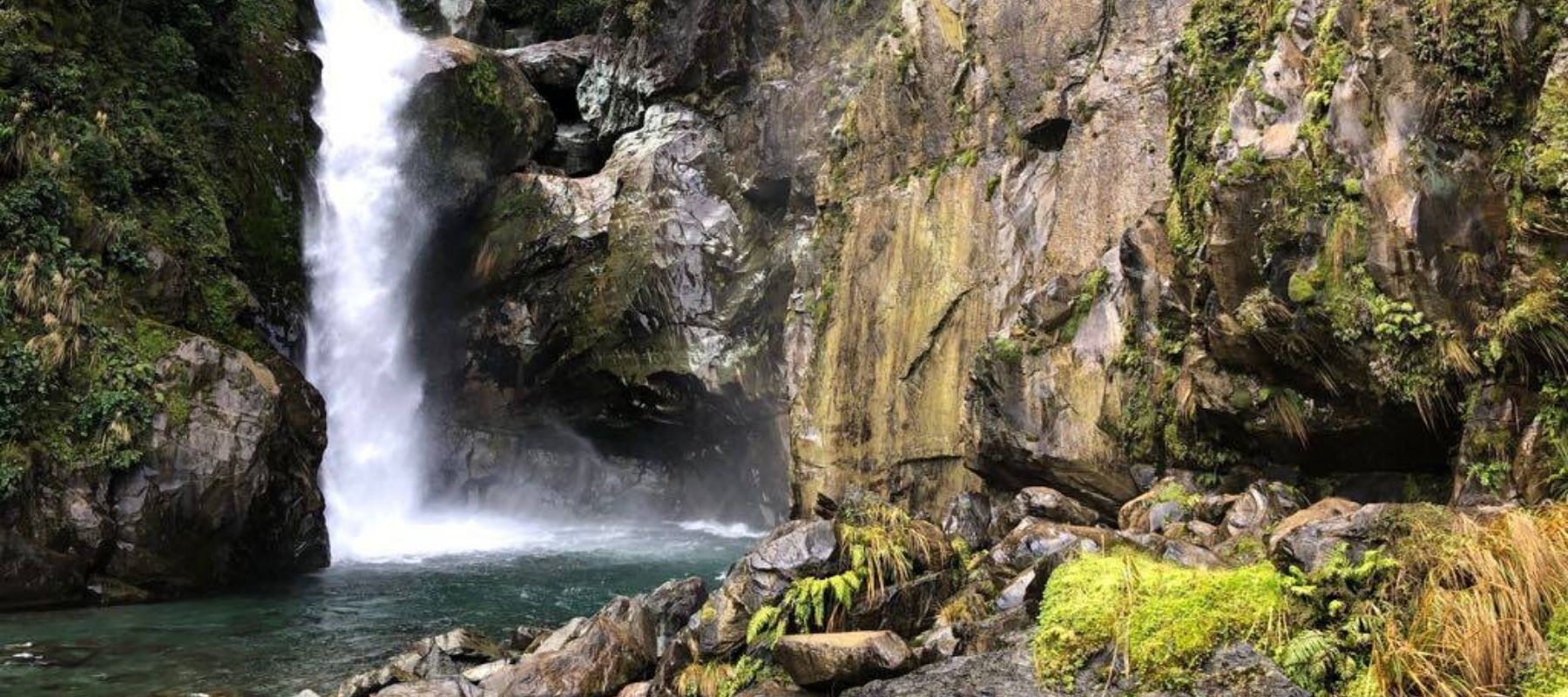
The Hollyford Track may not be as well known as its Fiordland neighbour the Milford Track, but it offers an unmatched diversity of scenery and rewards the smaller number of people who walk it handsomely.
Driving along the Milford Road past The Divide, on the descent into the Hollyford Valley, you will find the turn off for the start of the Hollyford Track.
STAY AT MILFORD SOUND LODGE BEFORE OR AFTER YOUR HOLLYFORD ADVENTURE
Stay a night or two at Milford Sound Lodge before or after you hike the Hollyford Track. Our well-appointed chalets are a real treat for weary hikers or choose to stay a night under the trees in a campervan. Beat the crowds with a morning boat cruise before heading back down the Milford Road. Bus transport makes it easy to organize your Hollyford Track adventure.
WALKING THE HOLLYFORD TRACK
At 56 kilometres it is longer than the Milford Track and other local walks like the Routeburn, Greenstone and Caples tracks. It takes four or five days to do and is open all year round because it doesn’t pass through any snowfields. Once you get to the other end, you can either fly out, retrace your steps, or book a seat on a jet boat and zoom back along the river!
This is perhaps the most diverse of all Fiordland’s great walks, with scenery ranging from lofty glaciers through lowland swamp, barren rock fields, forested lakes and coastal sand dunes. It runs along the Hollyford Valley to the surf-pounded sands of Martins Bay.
YOUR DESTINATION: MARTINS BAY
Martins Bay is a little way north of Milford Sound and had a brief flirtation with fame in the 19th century when big plans were made for it.
Martins Bay was well known to the Maori. They had a settlement there from about 1650 to the 1800s, to take advantage of the seafood, forest and lake foods, the greenstone, and the big trees that were ideal for canoe building.
But the Europeans didn’t know about the vast, green Hollyford Valley, or about Martins Bay, until a day in 1861 when two farmers, George Gunn and David McKellar, saw it from the top of Key Summit. For some reason, the coastal surveyor Captain Stokes, who had charted the coast aboard the Acheron in 1851, had missed Martins Bay, so it was left for the landlubbers to discover it years later.
DISCOVERY OF A SHORT-LIVED TOWN
Although Gunn and McKellar glimpsed the sparkling ocean at the far end of the green Hollyford valley from the top of Key Summit, the first recorded visit to the golden beaches of Martins Bay was paid by a man called Patrick Caples two years later.
He was walking from Otago in search of gold and was the first person to cross the Otago Peninsula from coast to coast. He followed the Hollyford River through Lake McKerrow, which he named, and out to the coast. When he reached Martins Bay he came across the Maori settlement there and got spooked in case they were hostile, so he didn’t stick around very long.
But the stories that Caples told when he got back were enough to inspire local whaler Captain Alabaster and two of his mates to check out the gold-mining prospects soon after. When they got to Martins Bay, they met an old Maori chief called Tutoko living there and didn’t find him to be unfriendly at all. Tutoko let them borrow his precious canoe, as they paddled up the river to explore Lake McKerrow! They thanked him by bestowing his name on the formidable Mount Tutoko, nearly three kilometres high.
THE GOLD RUSH & THE PORT THAT MIGHT HAVE BEEN
A few weeks after the trio returned to civilization, geologist Dr James Hector headed to Martins Bay too, naming two coastal mountains after Captain Alabaster’s two daughters, Sara and May. Hector went on to break through to Queenstown from the coast and proposed building a road from Queenstown to the bay and developing a port there.
This was an attractive idea because a coast link to Queenstown and shorter sailing route to Australia would improve the area’s gold trade enormously. Fiordland was in the grip of its gold rush, but getting the goodies out of the remote area was problematic so an efficient trade route would have been quite handy. But so far, the walking track remains the only land route to Martin’s Bay.
But the idea of building a port did get off the ground, and the handfuls of gold that people kept returning from the Bay with, ignited a small gold rush to the area. The superintendent of Otago, James Macandrew was an ardent advocate of developing the area, and the proposed settlement was named Jamestown in his honour. Work commenced on the banks of Lake McKerrow, a little way up-river from Martins Bay.
A BEAUTIFUL PLACE TO VISIT; A CHALLENGE FOR HARDY PIONEERS
The pioneering settlers arrived in 1870, although the first three or four boats that tried to enter the river from the bay all ran aground and the families on board lost most of their possessions.
Still, people are nothing around here if not resilient, and they persevered. Jamestown grew into a settlement of about eight houses, plus a store and a pub.
It was an uphill struggle for the settlers, though. The road to Queenstown did not appear to be happening, even when the idea was downgraded to a bridleway. And the so-called port wasn’t exactly bustling either. Every three months, a supply ship might chug past to service the town, but its delivery was often dumped on the beach because the boats couldn’t always get up the river. Sometimes it didn’t turn up at all, which made life in Jamestown pretty hard.
Within only a few years, most of the citizens of Jamestown had given up and moved on. Nowadays the town has been almost entirely reclaimed by the forest, with only a few apple trees and stone chimneys remaining.
A couple of families stayed on and stuck it out though, including the Mackenzies, who continued to keep cattle there until 1926. They sold up to legendary local Davy Gunn, no relation to George, who drove his cattle over 250 kilometres of rugged terrain every year for 29 years. Always ready to welcome tourists, Davy was sadly the last resident of Jamestown. After he drowned in the river in 1955, his homestead lay empty and abandoned.